|
| Section 10
How Well Does Restorations Work |
| RESTORATION
OF STREAM ECOSYSTEMS |
R.J. Rutherford,
Thaumas Environmental Consultants Ltd.
Dartmouth, Nova Scotia
bobrutherford@accesswave.ca
|
C. MacInnis
Department of Fisheries and Oceans
Antigonish, Nova Scotia.
902 - 863 - 5670 |
INTRODUCTION
Maritime streams have had a long history of use as transportation
routes, sources of power, waste removal and careless abuse due
to poor land use practices. Almost every watershed shows the
scars of numerous sawmills, grist mills, and water control dams
constructed during the 1800s and early 1900s (Dunfield, 1985).
Teams of horses pulling drags and later bulldozers worked streams
and rivers to 'improve' them for log driving. Artificial freshets
released from dams carried eight-foot saw logs and four-foot
pulp logs, which scoured the beds and banks as the forest was
harvested. The gravel flood plains were cleared to the banks;
meadowland and marshes were dyked and drained for farmland.
Power dams, many without fish passage, were constructed during
the 1920s, blocking major watersheds. Even in recent years,
streams have been straightened and moved to accommodate development,
gravel removed for construction, gravel bars and riffles have
been cleaned-out and channels straightened in the hope of improving
flow and reducing damage due to ice jams and flooding.
In 1918 to 1920 and again in the 1930's many farms were abandoned
and grew up in softwoods and through the 1960s forestry turned
away from log driving and water-powered saw mills. Enhancement
of streams for salmonids then concentrated on dam removal and
the provision of fish passage at power dams and natural obstructions.
Regional biologists and habitat managers felt that if they protected
the fish habitats from current anthropogenic impacts, nature
would quickly restore the streams to their former levels of
productivity. Emphasis was placed on erosion control (during
activities such as road construction), stream bank protection
and land use guidelines. This approach remains the main thrust
of fish habitat management programs, and with renewed public
concern for the environment in the 1990s it is showing visible
signs of success.
Despite improved habitat protection, salmonid populations are
still under stress and are declining. The focus of stock managers
remains on biotic factors such as low escapement, predation
(including overfishing), competition, disease, and in some watersheds
acidification due to acid rain. They hold to the view, that
all things being equal, the salmonid habitat should have restored
itself to historic production levels and current declines could
not be the result of physical habitat degradation because of
improved protection.
As part of the St. Mary's River Forestry Wildlife Project, salmonid
habitats were surveyed in areas of proposed harvesting so that
the impact of modern industrial forestry on the water quality
and physical salmonid habitats could be determined and mitigation
measures could be designed and implemented (Milton, 1990). The
survey found that even though the streams were surrounded by
sixty-year old or older forest, they were not very productive.
They retained the habitat characteristics typical of degraded
streams: a lack of pools, substrate embedded in silt and sand,
shallow warm summer flows, ice build up during winter low flows,
and a lack of summer escape cover and over wintering habitats.
Habitat ratings for Brook trout (Salvelinus fontinalis)
and Atlantic salmon (Salmo salar) indicated the physical
habitat would support 10% - 15% of its potential, which was
consistent or optimistic when compared with observed populations.
Subsequent investigations comparing highly productive habitats
and those with poor production in gravel/cobble bed streams
of similar size and flowing over the same geology found that
the major difference was in the amount of large organic debris
embedded in the substrate. Well-developed and diverse habitats
had an amazingly regular pattern of embedded hardwood logs approximately
six channel widths apart. This was the one ingredient that interacted
with stable vegetated banks, gradient, substrate size and flows
to sort gravels, develop bed forms and thalwegs (the deepest
part of a stream channel cross section) needed for high productivity.
Forest management practices and land use in general do not allow
for this regular input of hardwood debris. The restoration technique
developed from these observations is supported by extensive
literature (Leopold, 1964; Hunt, 1969; Burton, 1972; Newbury,
1994).
The low levels of salmonid production in these degraded habitats
were maintaining themselves because the Maritime weather provided
a good summer flow and kept water temperatures below harmful
levels. Over the past 30 years we have seen changes in the Maritime
climate. There has been a reduced snow pack, increasing summer
temperature, and changing rainfall patterns giving us less rain
in short intense storms. This climate change has been an added
stress on the freshwater habitats causing declining populations.
The streams with poor thalweg development and shallow pools
just about dried up. The wide shallow flows tracked air temperatures
and reached lethal levels and in the winter froze to the bottom.
The ice build up increased ice scour in the spring. Freshets
due to increased runoff in intense storms changed the size of
the one in two year flood widening streams and changing the
meander pattern. Slowly we have seen increased bank erosion
and infilling pools. Less perculation of water into the ground
has resulted in lower groundwater tables and lower base flows
in summer and over winter.
The good physical habitat has been able to withstand the changes
by holding more water in well-developed pools and cooling the
water through exchange with underground seeps.
CASE STUDY: BRIERLY BROOK
In 1992, a subwatershed restoration demonstration project was
identified as a priority under the Canada/Nova Scotia Recreational
Fisheries Planning Agreement. The agreement supplied some support
in the early years but much of the work has been done through
other funding sources and volunteer time.
Brierly Brook, a tributary to the West River at the town of
Antigonish, Nova Scotia was selected for the project as almost
a worst-case scenario. The brook was known to once have had
a good population of Atlantic salmon and sea run Brook trout,
which were currently in decline. Declines, in living memory,
appeared to be coincident with a series of instream modifications
(e.g., channelization, diversions), increasing ice jamming and
flooding problems, urban development (e.g. subdivisions with
little silt control, storm sewers, water pipelines, road crossings,
drains, and a flow/flood control dam) all of which took place
mainly during the 1960s and 1970s, but are still continuing
to some extent. Dispite better protection of the habitat the
fish populations continued to decline.
The watershed area is 33.2 sq. km and the brook flows from the
forested hills west of the town, through an area of mixed farming,
subdivisions and finally through the center of town. This gave
us a mix of all common land uses in the Maritimes in one small
area. The riparian zone was small to non-existent along the
lower half of the watershed. The forest throughout is young
and all significant dead wood was removed quickly especially
in the lower reaches. With the exception of high-suspended solids
and warm summer temperature, water quality was not a problem,
and the flow regime was typical of the best streams along the
Gulf of St. Lawrence shoreline. Rainfall patterns have shown
a tendency toward longer dry periods in the summer and short
higher intensity rainfall in storms. The study period has been
characterised by extremes in weather ranging from the longest
cold spell recorded in the winter of 1992/93 to the lowest rainfall
on record over the summer in a series of record breaking droughts
in eight of the past 10 years.
There were no obvious barriers to fish passage. All road crossings
are bridges and a flood control dam above the town is open to
passage except when extreme high flows create velocity barriers.
A raised water pipeline, caped with cement, in the lower reach
is a partial barrier in low flows but there is no evidence in
the data that it restricted migration.
The site is high profile, close to schools and universities,
community groups, government offices and the general public;
so it is an excellent education opportunity, which helps support
the clean up of ongoing problems.
The objective was to improve the productive capacity of the
fish habitat for Atlantic salmon and Brook trout. The focus
was on increasing juvenile habitat by providing low water refuges,
and lower silt loads. In achieving this we found that many other
problems such as ice jamming, ice scour of banks, poor over-winter
survival of parr, poor escapement into the upper reaches and
low wildlife populations were also mitigated. The objective
has now broadened to restoring the health and function of the
aquatic ecosystem.
THE
RESTORATION PLAN
The plan was based on knowledge of the physical habitat features
required by juvenile salmonids (Hynes, 1970; Raleigh, 1982);
the previously mentioned observations on large organic debris
and channel morphology (Leopold, 1964; Newbury 1994) that detailed
how the desired pool/riffle-sequence repeated every five to
seven channel widths.
The brook was surveyed beginning at its confluence with the
West River, which in natural watercourses represents a pool.
The distances along the centre line, between noticeable changes
in gradient, were noted and the channel width from the base
of terrestrial vegetation on one bank to the same position on
the opposite bank was recorded in areas where the brook had
good thalweg development. Stream widths in this area averaged
8 m between vegetated banks, and the channel capacity was consistent
with the one-in-two year flood channel. Breaks in gradient at
the lower end of runs were approximately 48 m apart, the six
channel widths expected. Since this time we have developed the
ability to calculate the width and spacing of pools based on
the one in two year flood using daily peak flows. This model
works well for watersheds where we have hydrology, as in Brierly,
and it does confirm the size and spacing used.
The natural pattern was hard to find because of shifts created
by human-made structures (exposed pipelines and bridges) and
past realignment of the brook, which had shortened the stream
length and placed sharp turns out of pattern. However, once
it was established, the pattern of a structure every six-channel
widths, fit to the current natural pattern in the brook, was
adhered to throughout the study section with only minor modifications
to accommodate in-stream features. This spacing was adjusted
as we moved upstream to be consistent with the one in two year
channel size at that point in the watershed.
IMPLEMENTATION
In the fall of 1992 the initial site at the mouth of the brook
in the town of Antigonish was installed as outlined below. Since
then additional work, using the same techniques, has been undertaken
on other badly degraded reaches extending upstream over 17 Km.
Bank rocking has been used to supplement the instream work at
severely eroding sites. The years the restoration was done in
each reach can be seen on the redd survey table.
To mimic large organic debris, which embeds itself at the change
in gradient from a riffle/run to a pool, digger logs (Figure
1) were the most common device used. Where the brook was
significantly wider than the design width, wing deflectors (Figure
2) were used alone, in pairs, or in combination with the
digger log.
Digger logs were sized on-site generally to be not more than
¼ of the bank height to the base of the vegetation. Logs averaged
15cm to 20 cm in diameter. They were placed across the stream
on a preferred angle of 30° from perpendicular to the flow.
The upstream end of the log was set lower than the downstream
end to concentrate low flows on the pool-side of the brook and
allow for improved fish passage. Logs were drilled every 2 m
to tightly accommodate a 1.5 cm rebar 1.25 m long, which was
driven through the log. Fifteen centimetres of the rod was bent
over to keep the log from floating up. Both ends of the log
were well rocked with stream cobble and small boulder to non-vegetated
channel height. A cobble/small boulder ramp was constructed
on the upstream side of the log on a 3:1 slope using material
from the downstream side where the pool was to form. This ramp
protected the log from ice and debris damage and formed a base
upon which gravels, sorted by the flow over the next couple
of years, collected to form spawning and fry nursery areas.
At many sites, in-stream rocks were so embedded they were unavailable,
and rock had to be brought in.
Deflectors were used where the channel was over-widened and
were placed with the digger logs in seven locations; in pairs
in four locations and singly in seven. Twenty-five digger logs
were place singly for a total of 43 locations over 2,064 metres
of stream. Deflectors have a 30°- 60°-90° triangle base with
the 30° at the upstream bank and the 90° instream; and are shaped
like the corner of a pyramid with the peak at bank height. The
instream point is located so that the point-to-bank width is
the design channel width. In combination with digger logs, deflectors
are on the most downstream end. In the four cases where the
deflectors are paired, the distance between the in-stream points
is 8 m. This layout was used where the channel width was very
wide (average 12.6 m) and both banks were eroding.
All devices were laid out to create pools on alternating sides
of the brook to fit and emphasise the meander pattern.
In 1993 the devices were checked. Boulders and cobble which
had appeared in the pool, as sands and silts moved out to the
point bars, were used to improve the ramps or, in some cases,
placed along the bank to allow the pool to scour deeper. These
rocks were placed back in the pool to provide more in-stream
cover after silts and sands have been flushed out a second time.
A seed mixture of reed canary grass and 'highway mix' was placed
on new bars and bare banks, along with willow cuttings. Minor
bank rocking (using small boulder and cobble placed by hand)
was done to protect bare banks unsuitable for planting.
The other restored sections, done in subsequent years, used
the same design and structures but the width and meander length
was adjusted to correspond to the one-in-two year channel at
that point in the watershed. The years each reach was restored
and the lengths of the reach can be found in the redd survey
data table.
DATA COLLECTION
Atlantic salmon and Brook trout habitats and populations were
sampled for each life stage. These include migration, spawning,
and each year class fry, one year olds (1+), two year olds (2+)
and three year olds (3+).
Salmon spawn in the fall. In this brook they begin to move into
the brook beginning in September with three distinct runs and
spawning in November and December, with the fish returning to
sea before freeze up. They bury the eggs in the gravel bed of
the brook up to 30cm deep in locations where the water draws
down through the gravel. Young hatch the following spring, remaining
in the river usually changing into smolts and moving to sea
the spring they turn two but some stay and leave in the spring
when they are three years old. Spawners return to the same brook
after one, two, or three years at sea.
Brook trout have a similar life history and may go to sea when
they are about 10 - 15 cm in length and only for a few months
at a time. If there are a lot of fish of this size in a small
brook, there will not be enough habitat during low flow periods
or through the winter and the fish then move to sea. Some stocks
appear to be more inclined to do this than others, but the objective
in sea trout stream restoration is to develop habitats suitable
to raise large numbers of trout to the 15cm size. This is also
the same habitat needed for Atlantic salmon but with more instream
cover.
A habitat survey was conducted in the fall of 1992, prior to
the installation of the devices, to determine average maximum
water temperature in the warmest summer period, average thalweg
depth, percent in-stream cover, quality and quantity of spawning
gravel, percent over winter habitat, escape cover, dominant
substrate type in riffle/run areas, percent pools during low
flow, bank vegetation, pool class, percent fines in spawning
and riffle/run areas, and percent shade (Hamilton, 1984). This
survey was repeated in 1993 and observations on the changes
of the habitat variables have been done annually.
Electrofishing was conducted in each year from 1992 to 1998
using a Smith Root Mark 12 electrofisher, following the Schnabel
method (Kaebs, 1989). This was initially done at two sites,
then expanded in later years as more restoration was completed.
A control site was established at the mouth of the brook, adjacent
to and downstream of the restoration site. A second control
site was chosen approximately 4.5 km above the uppermost structure.
All fish captured were identified and measured. Electrofishing
was repeated annually at the same sites.
Salmon redd surveys were conducted along the improved section
and control sites. This survey was conducted by walking the
stream and noting the location of spawners and redds on a bi-weekly
basis throughout the fall, beginning when the first signs of
spawning were noted and continuing until no new activity was
observed.
All data collection has been done or directly supervised by
the authors to maintain consistency of methodology, technique,
and observation quality.
RESULTS
Physical Habitat
Habitat survey information was interpreted using the Brook Trout
Habitat Suitability Index (Raleigh, 1982), and a habitat suitability
index for Atlantic salmon based on microhabitat studies in regional
rivers (Morantz, 1987). These indexes rate the physical and
chemical parameters, which commonly affect productivity, on
a scale for 0.00 to 1.00. These variables were then combined
to give suitability rating for each life stage. This rating
is closely correlated to population but cannot predict the standing
crop of fish since the model does not include the biological
factors, off-site physical factors or predation. Nevertheless,
it is a good indicator of a site's productive capacity or potential
to produce these species.
In 1992, adult trout habitat rated 0.20. The habitat was particularly
weak in thalweg depth and percent cover, but also weak in percent
pool and pool class. Juvenile trout habitat rated 0.30, with
weaknesses similar to the adult habitat. Fry and spawning habitats
both rated 0.00 due to the high percentage of silt and sand
in the substrate, which ranged from 20% - 80% on the surface
with all gravels and boulders fully embedded. Features common
to all life stages were weak on summer temperature (0.20), and
substrate quality (0.30), but were good for all other variables
including vegetation, shade, oxygen concentration and pH.
Atlantic salmon habitat had the same weaknesses, with large
parr habitat 0.30, juvenile habitat 0.30, and fry and spawning
habitat at 0.00.
One year later, in the fall of 1993, the survey was repeated
with greatly improved results. Adult trout habitat rating was
0.72 with improvements in all variables but still limited by
percent pool, pool class and cover. Juvenile habitat also improved
to a rating of 0.79, limited by percent pool and pool class.
Fry habitat improved to 0.85 limited by percent pool and spawning/embryo
habitat improved to 0.83. Atlantic salmon habitat in 1993 showed
even better improvement, with large parr habitat 0.77, juvenile
habitat near optimum 0.96, fry habitat 0.85 and spawning/embryo
habitat at 0.80. Improvements were also seen in summer temperature,
which lowered to within the optimum range, and in improvements
to substrate quality (0.60).
This survey has not been repeated in subsequent years but observations
on habitat quality indicate further improvements in pool quality
affecting the trout population and over-winter habitat for older
stages of salmon parr. Water temperatures have shown a further
improvement as a result of restoration work upstream. Fish populations
require a period of years to respond to such rapid increases
in habitat quality. Initially there is a slight increase in
population due to immigration then as the population grows it
fills the stream habitat.
Electrofishing
The following tables and accompanying charts (note the changing
scale on the y-axis) show the salmon and trout densities at
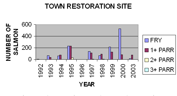
the control and restoration sites in the town of Antigonish.
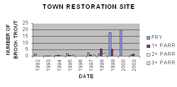
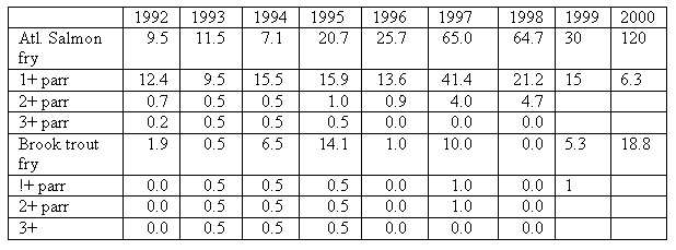
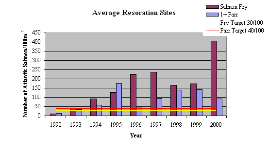
In town restoration site densities in fish/100m2
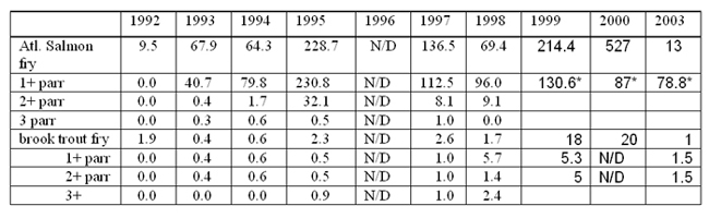
-total parr |
|
Electrofishing in the fall
of 1996 was not possible due to high flows. All 0's are actual
counts
In the winter of 1996 the lower-most structure and pool were
partially buried by flows diverted by ice from the main river.
This eliminated half of the restored electrofishing site and
this can be seen in lower populations in 1997. There was a slight
recovery of habitat features during 1997 but damage was caused
again in the winter by flows from the main river. Mergansers
beginning to feed in the site in 1998.
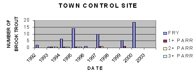
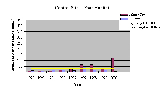
The in-town control site changed in habitat quality each year
as flows changed the bed form to give more or less water depth
and small scour pools. The changes are reflected in the changing
populations and age classes present. The productive capacity
of this site remained low.
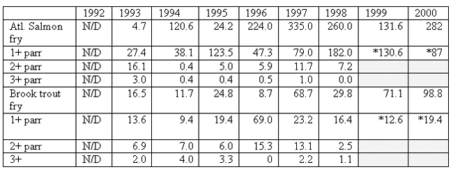
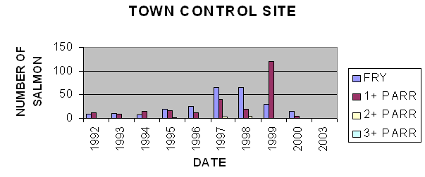
In-town control site, poor habitat, densities in fish/ 100m2
|
|
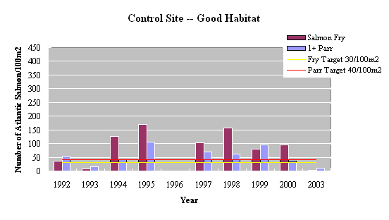
The upstream control site
was considered to be good habitat but was not supporting the
population that would be expected. The number of fish in the
site in recent years reflects expected densities because restoration
below allowed access by spawners. The drop between 1995 and
1997 reflects the improvements upstream that allowed spawners
to move up further. Populations in this area have not stabilised
yet and will likely move back to 1995 levels when the brook
is fully stocked.
Note the increases in the trout population. These densities
are among the highest in the Maritimes even though they are
combined with high densities of salmon.
Upstream control site, good habitat, densities in fish/ 100m2
|
|
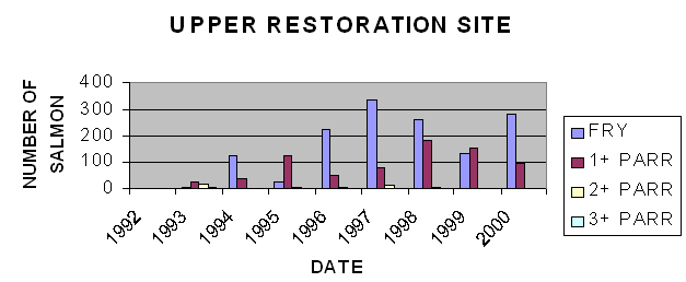
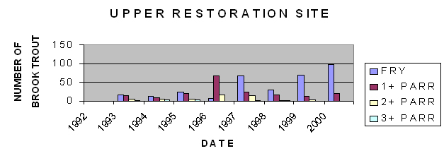
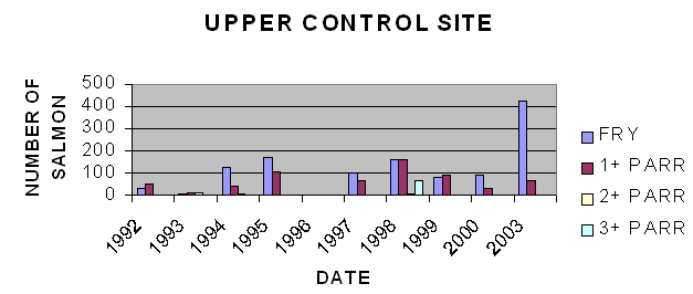
This site, located 13.4 km
from the mouth of the brook was restored in 1993 and is in a
steep forested section. The stream is typically described as
a trout stream and many salmon biologists have been surprised
to find salmon in this reach. Salmon densities have fluctuated
with access though the lower sections.
Again like the control site below we have high trout populations
with the salmon.
Upper Brierly Restoration Site |
Redd Survey
NUMBER OF REDDS PER 100
LINEAR METERS OF STREAM |
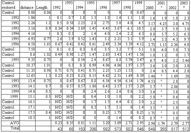
* Count was not completed this
year, spawning was latest ever due to drought conditions
* Count was completed this year; access to upper reaches
was block by beaver activity (multiple channels) |
- redd count low due to drought
conditions in the fall
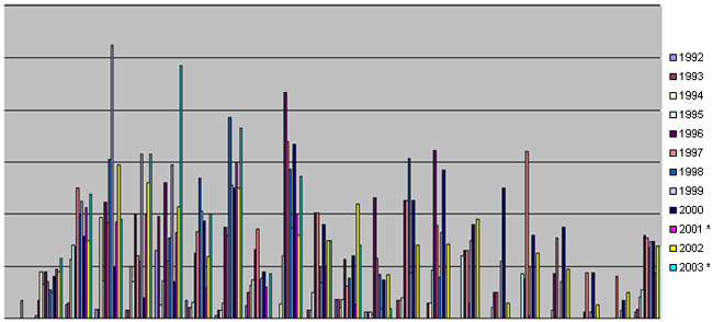
Redds per 100 linear metres of stream
X axis is by reach and the year the reach was restored,
with a coloured bar for each years redd counts. The
AVG is the average number of redds through out the 18.5
km of steam |
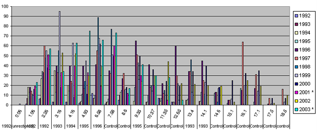
Total number of redds per reach
y axis is the actual number of redds in a reach. Note
that the reaches are of different lengths
x axis is years in coloured bars, length of stream reach,
and year of restoration/control site |
|
Observations
on the redd data.
- At the lowest control site, there was one redd in 1999 but
that was the only spawning seen in the site. Salmon and trout
juvenile populations in this area are emigrants from upstream
areas.
- At the downstream experimental site (2,200 m long) there were
no redds in 1991. The improvement devises were installed in
October 1992, just prior to salmon spawning. That year, there
were immediate results (0.6 redds/100m) and continuing yearly
increases to 6.4 redds/100m in 1997.
- The use of the restored sites for spawning in the year they
were installed is consistent in all sites. There is an immediate
increase followed by an additional increase over the next year
or two as the devices work with the flows to develop the habitats.
- This increase is not uniform with fish showing a preference
for sites with large organic debris.
- The upper Brierly site was restored in 1993 and showed a small
increase in spawning. This area was not well used until 1995
when a lower reach at 4.93km was restored and then increased
again in 1996 when section 6.58 was restored. Both these sites
restricted passage of salmon to the upper reaches.
- The level of 500 to 600 redds per year was reached before
increases in juvenile populations took effect. The rapid increase
in the number of redds indicates that the salmon were returning
to the brook but were limited in their ability to move up the
stream. The 1996 restoration was the final step in improving
passage in the lower reaches and the redd count more than doubled
in that year.
- This points out the need to start the restoration at the head
of tide and work up to connect fragmented habitats as a first
priority.
- Fall flows have long been recognized as bringing the fish
up the river. This is also the case in Brierly. In the fall
of 2001 the flows did not come and the redd counts were down
and passage into the upper reaches was blocked.
- In 2003 a large Beaver dam blocked and braided the channel
in the lower part of reach 12.65km, this effectively blocked
the migration to the upper reaches. However flows were good
and the fish spawned in the reaches below distributing themselves
throughout the lower brook.
- The concern here is that the fry densities will be very high
and may result in high mortality due to overcrowding of the
fry habitats. Fry, emerging from the redds, do not move far
and must have suitable habitat. If an optimum density is exceeded
then the survival of the fry could even be reduced below the
optimum carrying capacity. This is a critical or limiting density
dependent life stage of salmonids. If the redds are not well
distributed throughout the system, fry to parr survival may
limit the total population.
- The increase in juvenile production from egg to adult has
not increased the number of spawners. The increases are all
related to improved quality of spawning habitat and improved
migration habitats. This means the spawning is still limited
by the availability of pools and cover for adult salmon. This
fluctuates depending on flows but has reached a stable level.
- More work could be done to further improve this habitat that
may be a benefit in years of low flow but generally the brook
is well stocked with this level of spawning. The standard escapement
target is 240 eggs/ 100 sq m of rearing habitat. This spawning
level is approximately 800 eggs/ 100 sq m of rearing habitat
in years when they can reach the upper reaches.
Juvenile
population observations |
|
- These graphs show the
juvenile production of Atlantic salmon in combined restored
sites, good control habitats and poor control habitats
- The yellow line is the target level set for fry based on the
literature and our understanding of good habitat productivity
for this part of the Maritimes. The level is set at 30 fry/100
sq m of juvenile rearing habitat. This is the expected survival
from 240 eggs.
- The red line is the target level set for a combined parr count
(1+, 2+ and 3+).
- All electrofishing was done in the early to mid fall so fry
were really fall fingerlings and were easy to catch.
- The poor control habitat stayed below the target levels in
most years. This area was at the mouth of the brook and habitat
quality varied depending on how the flows had shaped the area.
The habitat was physically in better shape in 1997 and 1998
than in previous years. The populations also reflect spill over
from the other sections. There was only the one redd during
the study in 1999.
- The good control habitat was limited by the number of spawners
reflected in the 1992 and 1993 population levels. Improved spawning
raised the level but then densities appear to fluctuate with
the access to habitat further upstream.
- The restored habitat population built as the habitat improved
has out performed the good control. The 1992 data is just for
the lower restored site and the 1996 data is just for the upper
control site due to high flows. Parr densities were low in the
upper site because of limited spawning in the earlier years
and fry densities reflect the improved spawning in 1995.
-Restoration has clearly had a positive effect of juvenile densities.
DISCUSSION
Brooks, like Brierly Brook, have been impacted by direct human
intervention such as diversions, channelization, ice jam removal,
road crossings and log driving; as well as the indirect impacts
of poor land use, which results in increased sand and silt loads.
Individually or in combination, these impacts have left Maritime
streams approximately 20% overwidened, and dominated by runs
and flats with poorly sorted and embedded substrates. These
brooks consistently rate poorly on salmonid habitat models,
and better on white sucker (Catostomus commersoni), sculpin
(Cottus cognatus) and American eel (Anguilla rostrata)
models. The result is reflected in the fish populations. In
the case of Brierly Brook, there were white suckers, creek chub
(Semotilus atromaculatus), and sticklebacks (Gasteroteus
aculeatus) present in the experimental site during the 1992
electrofishing but none were found in 1993. Chub came back in
later years with much larger spawning individuals than previously
seen
Restoration of the site, using digger logs to imitate the missing component of large organic debris, required these logs to be carefully placed where flows had created breaks in the gradient. This pattern was established in reaches with narrow bank widths and followed without change through the wider reaches. In our past experiments with digger logs, we found that if this pattern of six channel widths is not followed, the effectiveness of the logs is reduced, some wash out and others are buried. In the case of Brierly Brook, none of the logs were lost to natural physical causes (two were removed by vandals and three were damaged by beavers) and all are working to improve habitat. This approach works with nature to form a stable brook with more diverse habitats.
Electrofishing results are consistent with the habitat ratings
and with the observed spawning. The improving conditions met
with an early response with increased number of redds although
survival from these redds, was likely low the first year due
to conditions which were still marginal and the sorting of gravels
during this first winter. The increased fry counts are due in
part to these redds, plus increased survival of migrants in
the improved habitat. In the first year of a restored site the
large increases in parr counts are due to increased survival
of migrants.
The wide shallow channel was a major factor in the warm, rapidly
fluctuating water temperature which lowered habitat quality
prior to 1992, and caused numerous fish kills. This channel
now has a good thalweg and pools acting to stabilise temperatures.
There were no fish kills in the improved sections. Previously
poor thalweg development caused problems in winter, when low
flows would freeze to the bottom, and minor thaws would flood
over the ice and freeze, causing a thick ice build-up. This
created a nice skidoo trail through town, but the spring thaw
lifted the ice cakes and surface gravels, skidding them downstream,
scouring the banks and bottom, and jamming at turns. The resulting
floods brought heavy equipment, which did additional damage.
The improved thalweg has made significant changes. In one of
the worst winters on record in 1992/93, the brook had very little
ice build-up and several sections stayed open. Ice jamming has
been minimal since the work was done, but ice still backs up
from the main river affecting the lower part of the restoration.
Nearby tributaries of the West River continue to have ice jamming
problems. In all restored sites the brooks never completely
freeze over, preventing ice build-up, ice jams and scouring
of streambeds and banks. Many eroding banks vegetated themselves
naturally.
In one example, 140 m of bank was proposed for riprap adjacent to a local campground. During the spring of 1993, there was no further erosion without the riprap. Over the summer, all but 30 m re-vegetated naturally. The remaining 30 m was rocked by hand with small boulders and cobble, then planted.
The cleaner substrate creates a rougher bottom that allows the
organics from the surrounding vegetation to deposit in the bottom
and compost to feed the food chain. This is very important in
Maritime streams which tend to be nutrient poor. Primary productivity
comes mainly from leaf fall in the riparian area. This enhanced
food chain is needed to support the increased fish population.
Great blue herons were a common sight along the brook in past summers, feasting on salmon parr. With improved water depth and instream cover, the fish are harder to catch and the herons have moved elsewhere.
Digger logs are more effective than deflectors at improving
habitat in a stream with this width and substrate size , especially
when placed at a 30° angle from the perpendicular to the flow.
There is no evidence that placing them at this angle will cause
bank erosion. In the work done in subsequent years, all logs
were placed this way regardless of the bank condition. The digger
logs cause water to scour the bottom with a plunging flow during
low flows, digging outward as the flows increase, producing
two to four standing waves downstream during bank full flows.
Fine gravels, sands and silts are layered with each freshet
on the point bar which forms to narrow the channel along the
bank adjacent to the downstream end of the log. During low flows,
these areas can be seeded with grasses, as mentioned before,
to speed up deposition. Pool and thalweg development continues
throughout the year with each freshet. Fluctuating flows do
the sorting, rather than just high flows. Very little material
is flushed downstream; most of it is redistributed to form new
banks, or the sands and silts are deposited on the flood plain.
The hardwood digger logs remain wet throughout the year and
do not show significant damage due to ice or moving gravels
if the upstream rock ramp is well installed. The rock ramp area
fills in with gravel, which is suitable for spawning. With the
head difference over the log, seepage through the gravel is
ideal. These areas were used by both salmon and trout, as were
more traditional sites at the tail of pools. Digger logs are
expected to remain for at least 25 years. The new channel should
be able to handle moderate suspended silt loads, depositing
them out of the main channel.
Changes in habitat quality were initially rapid, but slow as
they approached optimum levels over the next two to three years.
Fish populations followed, based on improved survival. For example,
Atlantic salmon fry which hatched in 1994 returned in 1999 as
grilse (one sea year salmon) and in 2000 as adults. Sea run
brook trout from the 1994 hatch were expected in 1999. However
the population also increases due to improved survival of the
fish already in the brook when restoration is done. So adult
returns began to rise in the first few years. We have found
that the brook was first fully stocked with salmon eggs in 1996
so full spawning returns were not expected until 2003. The returning
fish were unable to use the brook because it has limited holding
capacity for adults. The extra spawners moved up into the West
River system or return to sea.
The success of this project has acted as a catalyst for work
across the Maritimes and there are now over 60 watershed projects
directly restoring over 240km of stream. Each project is unique
in terms of the land-use problems to be solved, stream ecosystem
restoration plan, community involvement and the sources of support.
Most projects are completed through partnerships between several
federal, provincial and private sector funding sources, in-kind
support and a lot of volunteer time. In 2005 there will be a
$5 habitat stamp on angling licences in Nova Scotia and the
money will go toward habitat restoration through the Adopt-a-Stream
program administered by the nova Scotia Salmon Association.
REFERENCES
Barton, J.R., E.L. Peters, D.A. White and P.V. Winger. (1992).
Bibliography on the physical alteration of aquatic habitat
(channelization) and stream improvement. Provo, Utah: Bringham
Young University.
Dunfield, R.W. (1985). "The Atlantic salmon in the history of North America". Can. Spec. Publ. Fish. Aquat. Sci. 80: 181
Hamilton, K. and E.P. Berguson. (1984). Methods to estimate
aquatic habitat variables. Colorado: U.S. Fish and Wildlife
Service and Colorado State University.
Hunt, R.L. (1969). "Effects of habitat alteration on production, standing crops and yield of Brook trout in Lawrence Creek Wisconsin". Symposium on Salmon and Trout in Streams. T.G. Northcote (ed.). Vancouver, Canada: University of British Columbia. 281-312.
Hynes, H.B.N. (1970). The ecology of running waters.
Liverpool: Liverpool University Press.
Kaebs, J.K. (1989). Ecological methodology. New York:
Harper and Row.
Loepold, L.R., M.G. Walman and J.P. Miller. (1964). Fluvial processes in geomorphology. San Francisco: Freeman and Co.
Milton, G.R. and J. Towers. (1990). Fish habitat improvement structures and the forest industry. Antigonish, Nova Scotia: Report #6, St. Mary's River Forestry Wildlife Project.
Morantz, D 1994 internal DFO Maritimes Region report.
Newbury, R. W., Gaboury M., (1993) Stream analysis and Fish habitat Design, Gibons B.C. Newbury Hydraulics Ltd.
|
|


|
|
|
|

